


Model*
Not include shipping cost.
LINK-PP LPJ1075-1BHNL 100% Cross RTA-110AHQ1A UDE
United States
Carrier
CostDelivery TimeTracking
DHL
$ 31.97 3-7 daysAvailable
Fedex IP
$ 44.07 3-7 daysAvailable
DHL自定义
$ 51.37 3-7 daysAvailable
UPS Express Saver
$ 94.28 3-7 daysAvailable
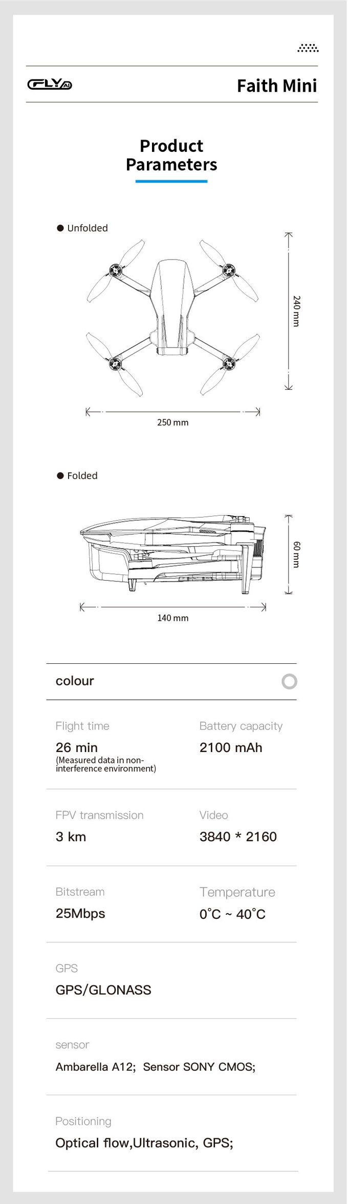
2100mAh 3D Mapping Drones Versatile Imaging Topographic Mapping Drone
3D Mapping Drones are topographical-mapping-drones with geographic-information-system capabilities. Their maximum ascend speed is 5m/s and their maximum decsend speed is 4m/s. The flight control is compatible with Mavlink Protocol Flight Control, and the wheelbase is 600mm,foldable. Also, the drones are equipped with satellite positioning systems, including GPS and GLONASS, for accurate data collection. With the combination of high speed, accurate positioning, and foldable wheelbase, 3D Mapping Drones can be used for numerous applications, including 3D mapping, surveying, geospatial data collection, and more.
| Parameter | Value |
|---|---|
| High-Resolution-Surveying-Drones | Yes |
| Three-Dimension-Mapping-Drones | Yes |
| Aerial-Photogrammetry-Mapping-Drones | Yes |
| Maximum Ascend Speed | 5m/s |
| Satellite Positioning Systems | GPS/GLONASS |
| Photo Format | JPEG |
| Flight Time(No Load) | 40mins |
| Flight Time(Full Load) | 29mins |
| Battery | 2100mAh |
| Max Service Ceiling Above Sea Level | 5000m |
| Maximum Decsend Speed | 4m/s |
| Flight Control | Compatible With Mavlink Protocol Flight Control |
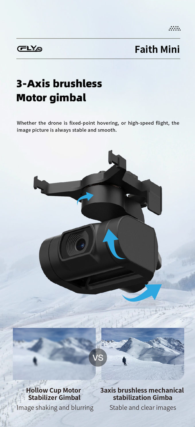
| Gimbal | 3-axis |
| 4G Extended Image Transmission | Global 4G Image Transmission, Unlimited Distance |
The Faith mini 3D Mapping Drone is a powerful Geographic-Information-System-Drones with a range of features designed to make High-Resolution-Surveying-Drones simpler and more efficient. It combines an Autonomous-Drone-Surveying with advanced 3D-Mapping-Drones technology to provide users with a reliable and accurate surveying tool. The 3D mapping drone is equipped with a 1080P 10km maximum distance, 4m/s maximum descent speed, 40 minutes flight time (without load) and 29 minutes flight time (with full load). It also features a maximum service ceiling above sea level of 5000m, and is capable of capturing photos in JPEG format. This drone is perfect for a variety of applications, such as surveying, mapping, search and rescue, inspection and many more. The Faith mini 3D Mapping Drone is available for a negotiable price with a minimum order quantity of 1 Pcs, and is shipped in standard packages with a delivery time of 3-7 work days. We accept payment via L/C, D/A, D/P, T/T, Western Union, and can supply up to 100,000 pcs per month.
Model Number: Faith mini
Place of Origin: China
Minimum Order Quantity: 1 Pcs
Price: Negotiable
Packaging Details: Standard Packages
Delivery Time: 3-7 work days
Payment Terms: L/C, D/A, D/P, T/T, Western Union
Supply Ability: 100,000 pcs per month
Flight Time: 40mins(no Load), 29mins(full Load)
4G Extended Image Transmission: Global 4G Image Transmission, Unlimited Distance
Maximum Distance: 1080P 10km
Photo: JPEG
Gimbal: 3-axis
This drone features a flight time of 40 minutes (no load) and 29 minutes (full load), as well as 4G extended image transmission with unlimited distance. It also has a maximum distance of 1080P 10km and a 3-axis gimbal for capturing high-quality JPEG photos.
The Faith Mini is capable of providing high-resolution surveying and geographic information system (GIS) operations, making it a perfect choice for applications that require the highest quality results.
Order now to experience the power of the Faith Mini 3D Mapping Drone!

1080P 10km 3D Mapping Drones Foldable Land Mapping Drone Customized

Custom Aerial Survey Drone Advanced Aerial Surveillance Drone For Surveying And Mapping

Mapping And Surveying Drones , Professional Drones For Surveying

1 Sold

Long Distance Heavy Lifting Drone Heavy Payload Drone With 29 mins Full Load Flight Time HK-DF816D

Powerful Heavy Load Carrying Drone 1080P 10km High Performance Drone

Aerial 3D Mapping Drones Foldable for Land Surveying

Faith Mini 3D Mapping Drones Land Surveying Drone For Aerial Mapping
1 Sold

Durable Remote Sensing Drone 3 Axis Gimbal Drones For Environmental Monitoring

Foldable Remote Sensing Drone 4m/S Professional Drone With HD Camera HK-DF812E
1 Sold

3 Axis Gimbal Load Bearing Drone 4m/s Cargo Carrying Drone Foldable
Long Distance Heavy Lifting Drone Heavy Payload Drone With 29 mins Full Load Flight Time HK-DF816D

High Range Aerial Survey Drone 17m/s Foldable 2 Axis Gimbal Drone HK-DF809G

1080P 10km Remote Sensing Drones Agriculture / Crop Monitoring Drone
1 Sold

Faith Mini 3D Survey Drone 1080P 10km UAV Mapping Drone With Strong Flight Performance
3 Axis Gimbal Load Bearing Drone 4m/s Cargo Carrying Drone Foldable
