


Not include shipping cost.
LINK-PP LPJ1075-1BHNL 100% Cross RTA-110AHQ1A UDE
United States
Carrier
CostDelivery TimeTracking
DHL
$ 31.97 3-7 daysAvailable
Fedex IP
$ 44.07 3-7 daysAvailable
DHL自定义
$ 51.37 3-7 daysAvailable
UPS Express Saver
$ 94.28 3-7 daysAvailable
Aerial 3D Mapping Drones Foldable for Land Surveying
Three-Dimension-Mapping-Drones are advanced aerial robots designed to capture data of the world around them. The drones are equipped with flight control systems that are compatible with the Mavlink Protocol Flight Control, a 2100mAh battery, a maximum ascend speed of 5m/s, a foldable 600mm wheelbase, and a camera that takes JPEG photos. These features make Three-Dimension-Mapping-Drones ideal for surveying and mapping a wide range of areas, providing detailed and accurate three-dimensional maps of the terrain. Three-Dimension-Mapping-Drones are reliable, efficient, and easy to use, giving you the ability to quickly and accurately capture data for whatever project you're undertaking.
| Parameter | Details |
|---|---|
| Product | Remotely-Operated-UAV-Mapping, High-Resolution-Surveying-Drones, Geographic-Information-System-Drones |
| Photo | JPEG |
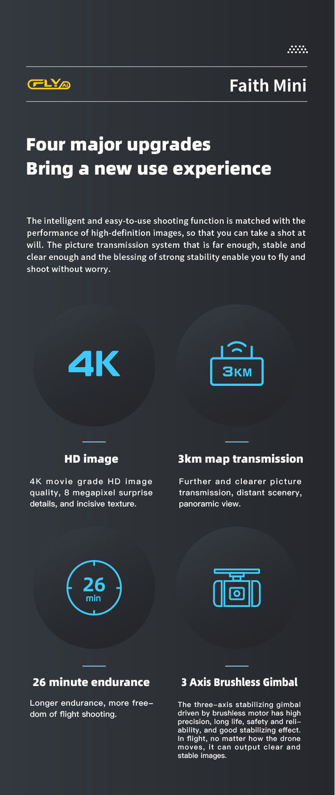
| Image Size | 3840*2160 |
| Maximum Decsend Speed | 4m/s |
| Maximum Ascend Speed | 5m/s |
| Maximum Distance | 1080P 10km |
| Max Service Ceiling Above Sea Level | 5000m |
| Flight Time | 40mins(no Load) ,29mins(full Load) |
| Wheelbase | 600mm,foldable |
| Battery | 2100mAh |
| Satellite Positioning Systems | GPS/GLONASS |
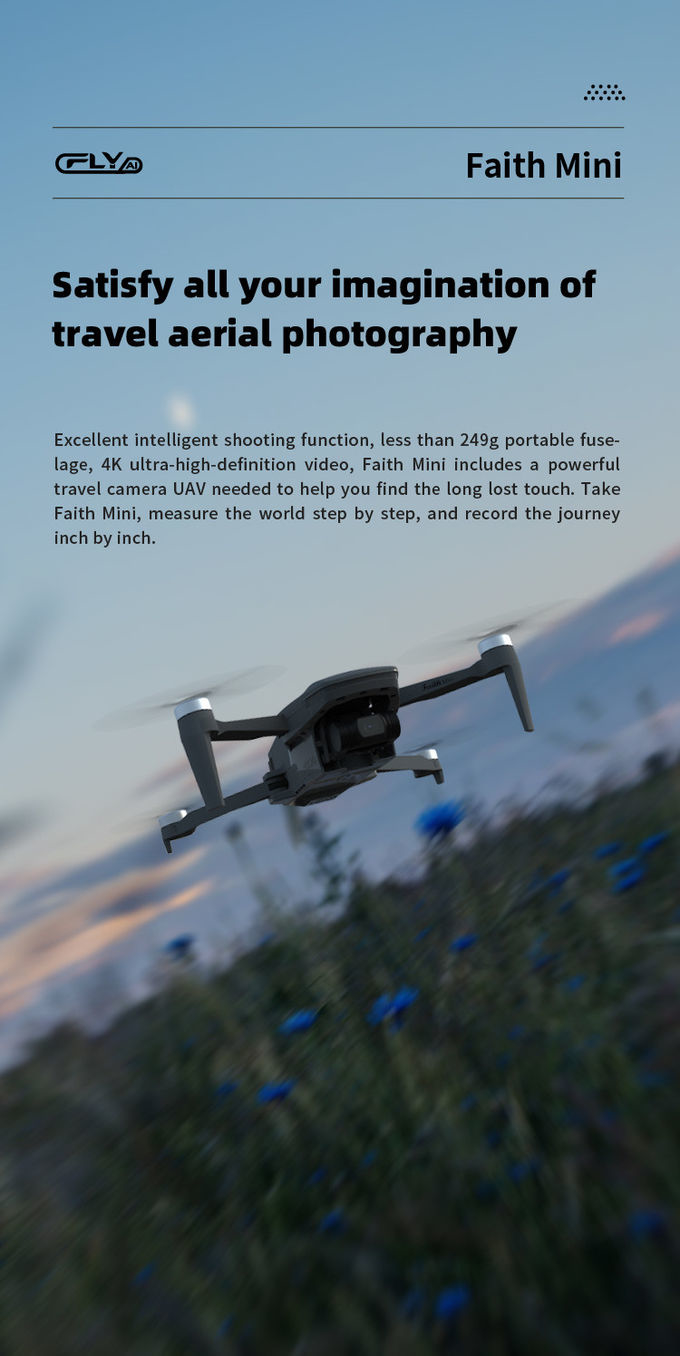
3D Mapping Drones, Faith mini, is a China-origin drone specifically designed for three-dimension mapping. With its maximum decsend speed of 4m/s, Flight time of 40 minutes (no load) and 29 minutes (full load), battery of 2100mAh, and satellite positioning systems of GPS/GLONASS, this drone is the perfect choice for three-dimension mapping. It also has a maximum ascend speed of 5m/s, making it a reliable and efficient tool for mapping. With a minimum order quantity of one piece, price that is negotiable, and standard packages for delivery, this 3D Mapping Drones, Faith mini is the ideal drone for three-dimension mapping. It is also capable of providing up to 100,000 pcs per month, with delivery time of 3-7 work days and payment terms of L/C, D/A, D/P, T/T, Western Union.
We offer customized 3D Mapping Drones, with Model Number Faith mini, Place of Origin China, Minimum Order Quantity 1 Pcs, Price Negotiatial, Packaging Details Standard Packages, Delivery Time 3-7 work days, Payment Terms L/C, D/A, D/P, T/T, Western Union, Supply Ability 100,000 pcs per month, Gimbal 3-axis, Max Service Ceiling Above Sea Level 5000m, Maximum Decsend Speed 4m/s, Photo JPEG, Operating Temperature Range -5-40℃.
Our Topographical-Mapping-Drones, 3D-Mapping-Drones and Remotely-Operated-UAV-Mapping-Platforms are of high quality and provide a reliable mapping solution.
A1: The model number of the 3D Mapping Drones is Faith mini.
A2: The 3D Mapping Drones is made in China.
A3: The minimum order quantity is 1 Pcs.
A4: The price is negotiable.
A5: The packaging detail is standard packages, and the delivery time is 3-7 work days.

1080p 4k Ultra HD Camera Drone Industrial Drones For Lifting HK-Faith Mini

4m/S 3D Mapping Drones For Surveying Land 3840*2160 Image Size

JPEG Photo Remote Sensing Drone 3 Axis Gimbal With Thermal Imaging Technology
2 Sold

Faith2 SE Aerial Survey Drone Foldable Remote Control Drone With Camera

Powerful Heavy Load Carrying Drone 1080P 10km High Performance Drone

Foldable 3D Mapping Drones For Topographic Mapping 3840*2160 HK-DF8166D

Precision Agriculture Drone 1080P 10km Environmental Monitoring Drone Remote Sensing

1080P 10km 3D Mapping Drones Foldable Land Mapping Drone Customized

High Range Aerial Survey Drone 17m/s Foldable 2 Axis Gimbal Drone HK-DF809G

Long Distance Heavy Lifting Drone Heavy Payload Drone With 29 mins Full Load Flight Time HK-DF816D
Long Distance Heavy Lifting Drone Heavy Payload Drone With 29 mins Full Load Flight Time HK-DF816D

Foldable Aerial Survey Drone Two Axis Gimbal Construction Site Drone Aerial Photogrammetry

2100mAh 3D Mapping Drones Versatile Imaging Topographic Mapping Drone

white Custom 3 Axis Gimbal Camera Drone For Construction Industry HK-DF846D

Aerial Inspection Drone Surveying And Mapping 4m/s Professional Photography Drones

Custom Aerial Survey Drone Advanced Aerial Surveillance Drone For Surveying And Mapping
