


Not include shipping cost.
LINK-PP LPJ1075-1BHNL 100% Cross RTA-110AHQ1A UDE
United States
Carrier
CostDelivery TimeTracking
DHL
$ 31.97 3-7 daysAvailable
Fedex IP
$ 44.07 3-7 daysAvailable
DHL自定义
$ 51.37 3-7 daysAvailable
UPS Express Saver
$ 94.28 3-7 daysAvailable
Faith2 SE Aerial Survey Drone Foldable Remote Control Drone With Camera
Specification
| 1 aircraft | |
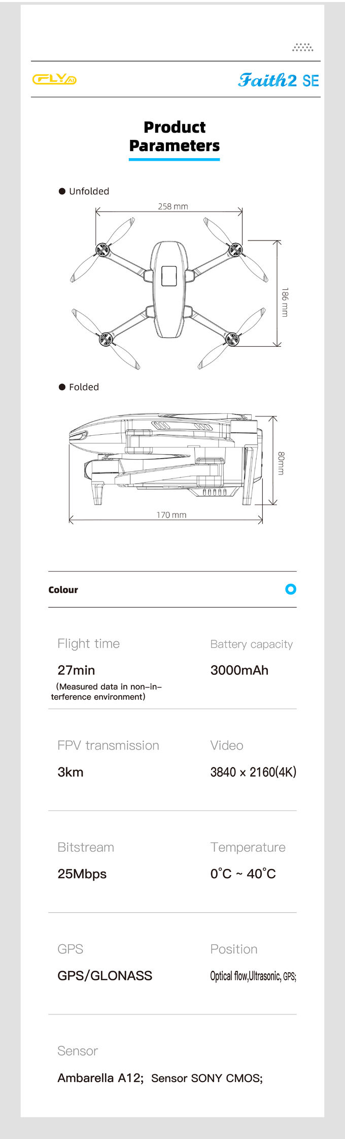
| Dimensions (including obstacle avoidance module, excluding paddle) | Expansion: length 186 × width 258 × height 112 mm Folded: length 167 × width 97 × height 112 mm |
| Diagonal wheelbase | 280mm |
| Weight (including battery, propeller and avoidance fault module) | 500 g (with three-axis gimbal) |
| maximum ascent speed | 4m/s (sports gear) 3m/s (normal speed) 3.5m/s (return mode) |
| maximum descent speed | 3m/s (sports gear) 2m/s (normal speed) 3m/s (return mode) |
| maximum horizontal flight speed | 14m/s (sports gear) 10m/s (normal speed) 12m/s (return mode) |
| Maximum flight altitude | 4000m |
| longest flight time | 27 minutes |
| Working temperature | 0°C to 40°C |
| Satellite positioning module | GPS/GLONASS dual mode |
| Hover accuracy | Vertical: +/- 0.5 meters ± 0.2 m (when optical flow positioning and ultrasonic height fixing are working normally) Level: +/- 1.5 meters ± 0.3 m (when optical flow positioning is working normally) |
| working frequency | 5.8GHz |
| flight altitude | Default 120 meters, maximum 500 meters (must manually change APP settings) |
| 2 Optical flow positioning system | |
| Optical flow positioning system | have |
| Usage environment | The surface has rich texture and sufficient lighting conditions (>15 lux, normal indoor fluorescent lighting environment) |
| Speed measurement range | Flight speed ≤ 1.5m/s (height 2 meters, sufficient light) |
| effective height | 0.5 ~6 meters |
| 3 Ultrasonic height-fixing system | |
| Ultrasonic height setting system | have |
| Usage environment | Except for water surfaces or floors made of absorbing materials (such as thick carpets) |
| Speed measurement range | Flight speed ≤ 3m/s |
| Height measurement range | 0.05 ~4.5 meters |
| 4 Obstacle avoidance system (optional) | |
| Obstacle avoidance type | Two-axis laser |
| Obstacle avoidance direction | 540°, front, back, left, right, up |
| Maximum detection distance | 20m |
| Maximum obstacle avoidance speed | 10m/s |
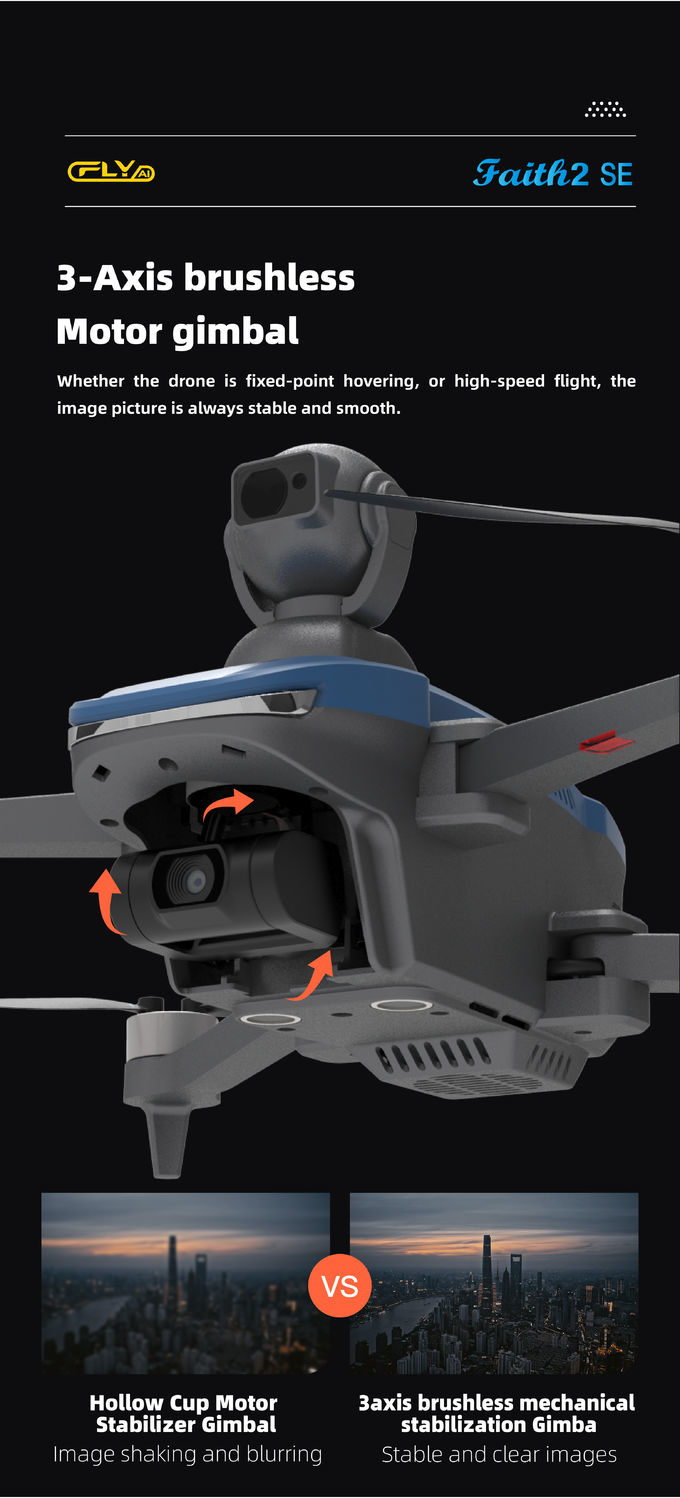
| 5 three-axis gimbal | |
| stabilization method | Mechanical stabilization of brushless motors |
| Controllable rotation range | Pitch: -90° to 0° (default setting) -90° to 20° (extended setting) |
| stable system | Three axes (pitch +35/-125°, roll ±35°, direction ±30°) |
| 6 Camera specifications | |
| image sensor | Sony Sensor CMOS |
| photo size | 3840x2160 (8 million) |
| Photo shooting mode | Single shooting, continuous shooting, time-lapse shooting |
| Record video maximum resolution | 3840×2160 (4K) 15FPS, 2716×1524 (2.7k) 25FPS |
| Maximum bit rate for recording video | 25Mbps |
| Support file system | FAT32 |
| Image Format | JPEG |
| video format | MP4 |
| Supported memory card types | MicroSD card, supports up to 128GB, Micro SD card with transfer speed reaching c10 rating. |
| Working temperature | 0°C to 40°C |
| 7 flight batteries | |
| capacity | 3000mAh |
| Voltage | 11.4V |
| Battery Type | LiPo 3S |
| energy | 29.64 Wh |
| Overall battery weight | About 170g |
| Working temperature | 0°C to 40°C |
| Maximum charging power | 29W |
| Charging time | < 4h (using 5V 2A power adapter) |
| 8 APP/image transmission | |
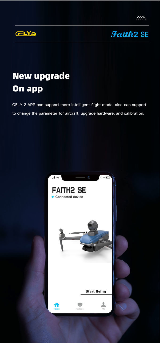
| Mobile App | CFLY 2 |
| Real-time image transmission | Maximum 720P, will automatically switch the resolution according to environmental conditions |
| Maximum image transmission distance | 3000m |
| Aerial photography mode | Fading away mode, surround mode, skyrocketing mode, spiral mode |
| Mobile phone system version requirements | Andrio 6.0 or above, IOS 10.0 or above |
| 9 charger | |
| enter | 5V 2A (recommended, the power of the power adapter determines the charging time) |
| output | 4.35V 0.7A×3 |
| rated power | 10 W |
| 10 remote control | |
| working frequency | 5.8GHz |
| Maximum signal effective distance | 3000m |
| Equivalent isotropic radiated power (EIRP) | <26 dBm (FCC), <20 dBm (CE/SRRC/MIC) |
| Working current | 700mA |
| Mobile device holder | Thickness 6.5-8.5 mm, maximum length 80 mm |
| battery capacity | 2600 mAh |
| Length of use | 2.5h (different mobile phones will vary) |
| battery voltage | 3.7V |
| Battery Type | LiPo 18650 |
| Battery energy | 9.62 Wh |
| Working temperature | 0°C to 40°C |
| charging method | USB |
| Maximum charging power | 10W |
| Charging time | < 2.5h (It is recommended to use a 5V 2A power adapter, its power determines the charging time) |
Description
Aerial Survey Drone, also known as an UAV (Unmanned Aerial Vehicle) or UAS (Unmanned Aerial System) for aerial surveying, is an unmanned aircraft equipped with specialized sensors and cameras used to capture high-resolution imagery and data from an aerial perspective for surveying and mapping applications. These drones are specifically designed for conducting surveys and collecting geospatial information efficiently and accurately.
Features
Applications

JPEG Photo Remote Sensing Drone 3 Axis Gimbal With Thermal Imaging Technology
2 Sold

Faith Mini 3D Mapping Drones Land Surveying Drone For Aerial Mapping
1 Sold

Two Axis Aerial Imaging Drone 1080P 10km Construction Monitoring Drone HK-DF809G

Long Distance Heavy Lifting Drone Heavy Payload Drone With 29 mins Full Load Flight Time HK-DF816D

High Range Aerial Survey Drone 17m/s Foldable 2 Axis Gimbal Drone HK-DF809G

3 Axis Gimbal Drone High Performance For Fire Rescue Power Patrol HK-DF816D

Folding Remote Control RC Drone Rechargeable With Strong Flight Performance HK-DF816D

3 Axis Gimbal Load Bearing Drone 4m/s Cargo Carrying Drone Foldable

1080p 4k Ultra HD Camera Drone Industrial Drones For Lifting HK-Faith Mini
Long Distance Heavy Lifting Drone Heavy Payload Drone With 29 mins Full Load Flight Time HK-DF816D

1 Sold

Mapping And Surveying Drones , Professional Drones For Surveying

Aerial Photogrammetry Drone Foldable 3D Scanning Drone For Topographic Survey

Foldable Aerial Survey Drone Two Axis Gimbal Construction Site Drone Aerial Photogrammetry

Precision Agriculture Drone 1080P 10km Environmental Monitoring Drone Remote Sensing

2100mAh 3D Mapping Drones Versatile Imaging Topographic Mapping Drone
