


Not include shipping cost.
LINK-PP LPJ1075-1BHNL 100% Cross RTA-110AHQ1A UDE
United States
Carrier
CostDelivery TimeTracking
DHL
$ 31.97 3-7 daysAvailable
Fedex IP
$ 44.07 3-7 daysAvailable
DHL自定义
$ 51.37 3-7 daysAvailable
UPS Express Saver
$ 94.28 3-7 daysAvailable
Aerial Photogrammetry Drone Foldable 3D Scanning Drone For Topographic Survey
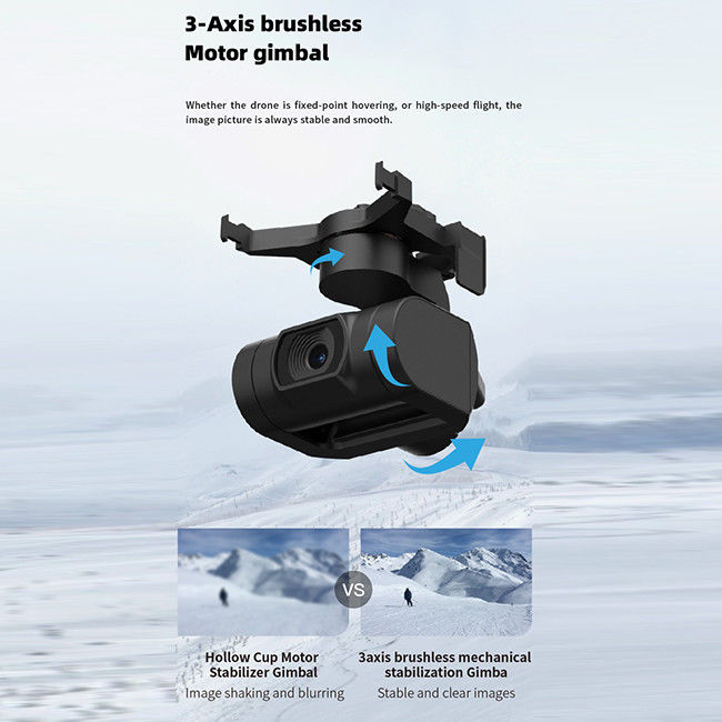
3D Mapping Drones are Unmanned Aerial Vehicles (UAVs) specifically designed for Geographic-Information-System-Drones (GIS) and Aerial-Photogrammetry-Mapping-Drones. They are equipped with Satellite Positioning Systems like GPS/GLONASS for precise positioning. They have a 3-axis Gimbal and can take high-resolution JPEG photos with an Image Size of 3840*2160. These drones are capable of operating in temperature range of -5-40℃, making them suitable for mapping activities in a wide variety of geographical regions. With 3D Mapping Drones, you can record and store aerial data more efficiently and accurately, helping to make the data more useful for GIS mapping projects.
| Specification | Detail |
|---|---|
| Wheelbase | 600mm, foldable |
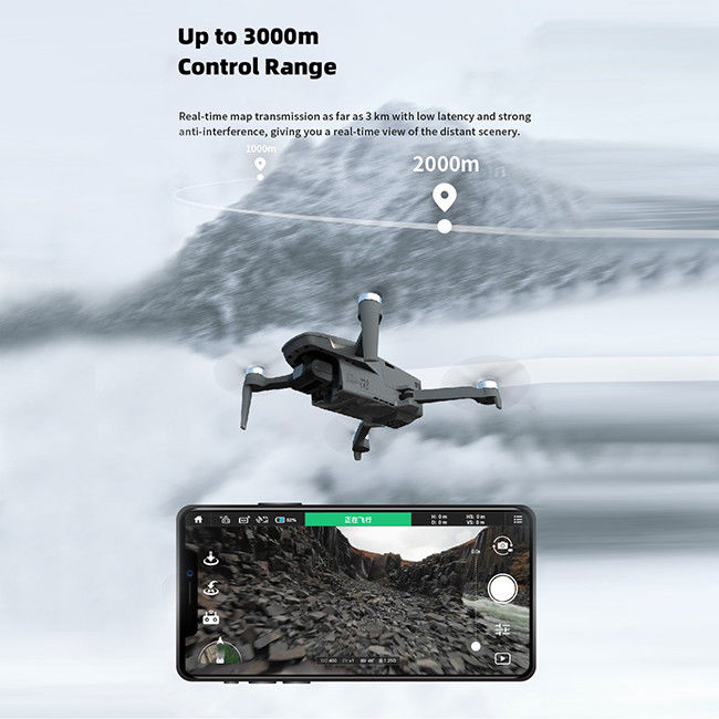
| Maximum Distance | 1080P 10km |
| Satellite Positioning Systems | GPS/GLONASS |
| Max Service Ceiling Above Sea Level | 5000m |
| Battery | 2100mAh |
| Photo | JPEG |
| Maximum Descend Speed | 4m/s |
| Flight Time | 40mins(no Load),29mins(full Load) |
| Flight Control | Compatible With Mavlink Protocol Flight Control |
| 4G Extended Image Transmission | Global 4G Image Transmission, Unlimited Distance |
| Keywords | Geographic-Information-System-Drones, Robotic-Mapping-Aircrafts, High-Resolution-Surveying-Drones |
3D Mapping Drones, also known as Aerial Photogrammetry Mapping Drones, are the latest innovation of aerial mapping technology. The Faith mini, produced in China, is one of the most sought-after models due to its affordability and high performance. It comes with standard packaging and can be delivered in just 3-7 work days. Payment terms include L/C, D/A, D/P, T/T, and Western Union, with a maximum capacity of up to 100,000 pcs per month. It has a maximum decsend speed of 4m/s and a maximum ascend speed of 5m/s and comes with a 2100mAh battery. The image size is 3840*2160 and it has a global 4G image transmission with unlimited distance.
Our 3D Mapping Drones are designed to provide high-resolution surveying and autonomous drone surveying, making them ideal for three-dimensional mapping applications. These drones are equipped with powerful features, such as a foldable wheelbase of 600mm, a 3-axis gimbal, and a maximum descend speed of 4m/s, for ensuring smooth operation and long-lasting performance. In addition, the 4G extended image transmission offers global 4G image transmission with unlimited distance. Other features include an operating temperature range of -5-40℃.
Our 3D Mapping Drones are suitable for a variety of applications, such as surveying, mapping, aerial photography, inspection, and more. With their high performance and reliable design, these drones are perfect for your autonomous drone surveying and high-resolution surveying projects.
Q: Are you a manufacturer or trade company?
A: We are the manufacturer.
Q: Do you accept customization?
A: Yes, we accept customization both on software & hardware and logo branding, color boxes, as well as packaging.
Q: What is your warranty policy?
A: One-year warranty, replacement, or repair services shall be provided under non-artificial quality issues.
Q: What's your MOQ?
A: Our MOQ is 1000pcs, trial orders, and samples are also available.
Q: How about the lead time and delivery time?
A: The stocked sample shall be sent out within 1-3 days after payment is received if the model is stocked
The lead time for mass quantities will be sent out within 30-35 days.
Delivery time : 3-7 days to arrive at destination after delivery if sent by international express like DHL, UPS, FedEx, etc.
Sea Transportation: 25-30 days after sailing
Q: How long does it take for the Infrastructure Inspection Drone to be delivered?
A: The Infrastructure Inspection Drone will be delivered within 3-7 work days.
Q: Do you provide SKD service?
A: Yes, we can do SKD orders, if your company can assemble yourself, the MOQ is 1000pcs.
Q: What is the Supply Ability for the Infrastructure Inspection Drone?
A: The Supply Ability for the Infrastructure Inspection Drone is 100,000 pcs per month.
Q: Where are the drones shipped from?
A: We send drones from our Shenzhen factory, or we can send them from Vietnam and the Philippines.
Q: Do you provide any value-added services for particular purposes?
A: We can dispatch our professional engineers to your company for drone assembly if your order quantity reaches our requirements.

Two Axis Aerial Imaging Drone 1080P 10km Construction Monitoring Drone HK-DF809G

Durable Remote Sensing Drone 3 Axis Gimbal Drones For Environmental Monitoring

3 Axis Gimbal Load Bearing Drone 4m/s Cargo Carrying Drone Foldable

1080p 4k Ultra HD Camera Drone Industrial Drones For Lifting HK-Faith Mini

1080P 10km Remote Sensing Drones Agriculture / Crop Monitoring Drone
1 Sold
3 Axis Gimbal Load Bearing Drone 4m/s Cargo Carrying Drone Foldable

Mapping And Surveying Drones , Professional Drones For Surveying

Foldable Remote Sensing Drone 4m/S Professional Drone With HD Camera HK-DF812E
1 Sold

Faith2 SE Aerial Survey Drone Foldable Remote Control Drone With Camera

Foldable 3D Mapping Drones For Topographic Mapping 3840*2160 HK-DF8166D

Custom Aerial Survey Drone Advanced Aerial Surveillance Drone For Surveying And Mapping

Aerial 3D Mapping Drones Foldable for Land Surveying

Foldable Aerial Survey Drone Two Axis Gimbal Construction Site Drone Aerial Photogrammetry

Precision Agriculture Drone 1080P 10km Environmental Monitoring Drone Remote Sensing

3 Axis Gimbal Drone High Performance For Fire Rescue Power Patrol HK-DF816D

Long Distance Heavy Lifting Drone Heavy Payload Drone With 29 mins Full Load Flight Time HK-DF816D
