


Not include shipping cost.
LINK-PP LPJ1075-1BHNL 100% Cross RTA-110AHQ1A UDE
United States
Carrier
CostDelivery TimeTracking
DHL
$ 31.97 3-7 daysAvailable
Fedex IP
$ 44.07 3-7 daysAvailable
DHL自定义
$ 51.37 3-7 daysAvailable
UPS Express Saver
$ 94.28 3-7 daysAvailable
Two Axis Aerial Imaging Drone 1080P 10km Construction Monitoring Drone HK-DF809G
Our Aerial Survey Drone is a high-performance, aerial photogrammetry drone, aerial observation drone, and aerial imaging drone that is perfect for a variety of surveying, mapping, and inspection missions. With its high-efficiency brushless motors and foldable wheelbase, the drone is able to take off and fly quickly in even the most challenging environments. It has a flight time of 40 minutes with no load and 29 minutes with full load, and a maximum distance of 10 km when capturing 1080P images. Its GPS/GLONASS satellite positioning system is highly accurate and reliable, and it is designed to operate in temperatures ranging from -5 to 40 ℃. Whether you need to survey an area, map a construction site, or inspect a power line, our Aerial Survey Drone is the perfect tool for the job.
| Parameter | Value |
|---|---|
| Aerial Survey Drone | Aerial Mapping Drone, Aerial Observation Drone |
| 4G Extended Image Transmission | Global 4G Image Transmission, Unlimited Distance |
| Operating Temperature Range | -5-40℃ |
| Screen Type | LCD |
| Maximum Distance | 1080P 10km |
| Maximum Speed | 17m/s |
| Take Off Weight | About 3178g |
| Maximum Ascend Speed | 4m/s |
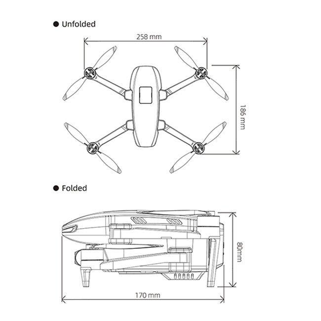
| Wheelbase | Foldable |
| Satellite Positioning Systems | GPS/GLONASS |
Aerial Surveillance Drone has become an essential tool for many industries. The Faith2 SE model, made in China, is an excellent choice for aerial photogrammetry. With a minimum order of 1 pcs and a price that is negotiable, it is packaged in standard packages and will be delivered within 3-7 workdays. You can choose from a variety of payment methods, including L/C, D/A, D/P, T/T, and Western Union. With a maximum production of 100,000 pcs per month, its maximum ascend speed is 4m/s and its 4G extended image transmission is global and unlimited in distance. Its takeoff weight is about 3178g and its maximum distance is 1080P 10km. Finally, its wheelbase is foldable.
Model Number: Faith2 SE
Place of Origin: China
Minimum Order Quantity: 1 Pcs
Packaging Details: Standard Packages
Delivery Time: 3-7 workdays
Payment Terms: L/C, D/A, D/P, T/T, Western Union
Supply Ability: 100,000 pcs per month
Maximum Speed: 17m/s
Flight Control: Compatible With Mavlink Protocol Flight Control
Maximum Ascend Speed: 4m/s
Gimbal: Two Axis
Maximum Decsend Speed: 3m/s

Q: Are you a manufacturer or trade company?
A: We are the manufacturer.
Q: Do you accept customization?
A: Yes, we accept customization both on software & hardware and logo branding, color boxes, as well as packaging.
Q: What is your warranty policy?
A: One-year warranty, replacement, or repair services shall be provided under non-artificial quality issues.
Q: What's your MOQ?
A: Our MOQ is 1000pcs, trial orders, and samples are also available.
Q: How about the lead time and delivery time?
A: The stocked sample shall be sent out within 1-3 days after payment is received if the model is stocked
The lead time for mass quantities will be sent out within 30-35 days.
Delivery time : 3-7 days to arrive at destination after delivery if sent by international express like DHL, UPS, FedEx, etc.
Sea Transportation: 25-30 days after sailing
Q: How long does it take for the Infrastructure Inspection Drone to be delivered?
A: The Infrastructure Inspection Drone will be delivered within 3-7 work days.
Q: Do you provide SKD service?
A: Yes, we can do SKD orders, if your company can assemble, the MOQ is 1000pcs.
Q: What is the Supply Ability for the Infrastructure Inspection Drone?
A: The Supply Ability for the Infrastructure Inspection Drone is 100,000 pcs per month.
Q: Where are the drones shipped from?
A: We send drones from our Shenzhen factory, or we can send them from Vietnam and the Philippines.
Q: Do you provide any value-added services for special purposes?
A: We can dispatch our professional engineers to your company for drone assembly if your order quantity reaches our requirements

4m/S 3D Mapping Drones For Surveying Land 3840*2160 Image Size

2100mAh 3D Mapping Drones Versatile Imaging Topographic Mapping Drone

3 Axis Gimbal Load Bearing Drone 4m/s Cargo Carrying Drone Foldable

Precision Agriculture Drone 1080P 10km Environmental Monitoring Drone Remote Sensing

Foldable 3D Mapping Drones For Topographic Mapping 3840*2160 HK-DF8166D

JPEG Photo Remote Sensing Drone 3 Axis Gimbal With Thermal Imaging Technology
2 Sold

Mapping And Surveying Drones , Professional Drones For Surveying

3D Aerial Photogrammetry Drone / Land Mapping Drone With 3 Axis Gimbal

Custom Aerial Survey Drone Advanced Aerial Surveillance Drone For Surveying And Mapping

High Range Aerial Survey Drone 17m/s Foldable 2 Axis Gimbal Drone HK-DF809G

Faith Mini 3D Survey Drone 1080P 10km UAV Mapping Drone With Strong Flight Performance

1080P 10km 3D Mapping Drones Foldable Land Mapping Drone Customized
3 Axis Gimbal Load Bearing Drone 4m/s Cargo Carrying Drone Foldable

Foldable Aerial Survey Drone Two Axis Gimbal Construction Site Drone Aerial Photogrammetry

Aerial 3D Mapping Drones Foldable for Land Surveying

1 Sold
