


Model*
Not include shipping cost.
LINK-PP LPJ1075-1BHNL 100% Cross RTA-110AHQ1A UDE
United States
Carrier
CostDelivery TimeTracking
DHL
$ 31.97 3-7 daysAvailable
Fedex IP
$ 44.07 3-7 daysAvailable
DHL自定义
$ 51.37 3-7 daysAvailable
UPS Express Saver
$ 94.28 3-7 daysAvailable
ZAi Drones Faith Mini 2 For Commercial Aerial Photography 30FPS 4K HD Photos For Media Video Production
ZAi Drones Faith Mini 2 For Commercial Aerial Photography 30FPS 4K HD Photos For Media Video Production
Product Application
Our Faith mini 2 is the upgraded version of Faith mini drones, it can be used for commercial aerial photography, media production, traveling, adventure, selfie,parent-child games, patrol, forest protection, dangerous patrol ane, etc.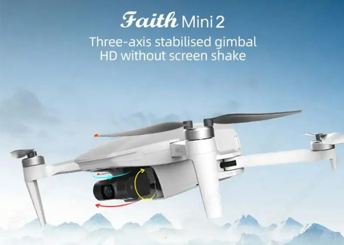
Product Parameters
| Aircraft | ZAi Drone Faith Mini 2 |
| product name | ZAi Drone Faith Mini 2 |
| keywords | ZAi Drone/ Faith Mini 2 For Commercial Aerial Photography |
| model number | Faith Mini 2 |
| size | Unfold:165 X 188 X 59 mm (L*W*H) Folded:142 X 84 X 57 mm(L*W*H) |
Wheelbase | 218 mm |
| max flight time | 33 minutes |
Max Transmission Distance | 5000m |
Weight (Battery & Propellers Included) | under 250g |
Max Ascent Speed | 5m/s(sport mode) 3m/s(Normal mode) 2m/s(Calm mode) 3.5m/s(RTH mode) |
Max Descent Speed | 3.5m/s(sport mode) 3m/s(Normal mode) 1.5m/s(Calm mode) 3m/s(RTH mode) |
Max Service Ceiling Above Sea Level | 4000 m |
Operating Temperature Range | 0°C~40°C |
Satellite Positioning Systems | GPS/GLONASS |
Hover Accuracy Range | vertical: +/- 0.5 m horizontal: +/- 1.5m ± 0.3 m(optical flow system works) |
Operating Frequency | 2.4GHz |
Maximum flight height | 120m,maximum 800m (set on app) |
Optical flow system | Yes |
Operating Environment | Surface with clear pattern and adequate lighting (lux > 15) |
Velocity Range | ≤1.5 m/s at 6.6 ft (2 m) above ground |
Altitude Range | Range 0.02~4m |
3-axis gimbal Stabilization | 3-axis(pitch:+30/-120°,roll:± 30°,course:±30°) |
Controllable Range | pitch:-90°~15° |
Jitter Amount | 0.01° |
APP | C-Fly 2 |
Live View Quality | 1080p, automatically changes definition based on condition |
Maximum FPV transmission distance | 5000m |
Aerial photography mode | dronie, rocket, circle, helix, boomerang, delay, live show, Vertical screen, Panoramic |
Required Operating Systems | Andriod 5.0 above, IOS 10.0above |
Charger | |
Input | 5 V 2A(recommend) |
| output | 4.4V 1A×2 |
Remote Controller | Operating Frequency |
Max Transmission Distance | 5000m |
Operating Temperature Range | 0°C~40°C |
Operating Current/Voltage | 700mA/3.7V |
Supported Mobile Device Size | Thickness Supported:6.5-8.5mm |
Battery capacity(built-in) | 3.7v 3000 mAh |
Battery type | LiPo 18650 |
Battery power | 11.1Wh |
Charge | USB |
Maximum charge power | 10W |
charge time | < 2.5h(with 5V 2A adapter) |
Selling Points
1. Flight control upgraded 2.0: Optimised GPS and magnetic compass anti-jamming performance, optical flow positioning height increased to 10mautomatic GPS mode switching
2. Three-axis stabilized gimbalHD without screen shake
3. SNOY camera, what one sees is remarkable: Professional-grade camera, effective noise suppression in low light, better image resolution, and higher dynamic range
4. 4K video, level 5 wind resistance, 5km enhanced FPV,4X digital zoom
5. Lighter than 249g, no registration required
6. Automatic return it's not easy to get lost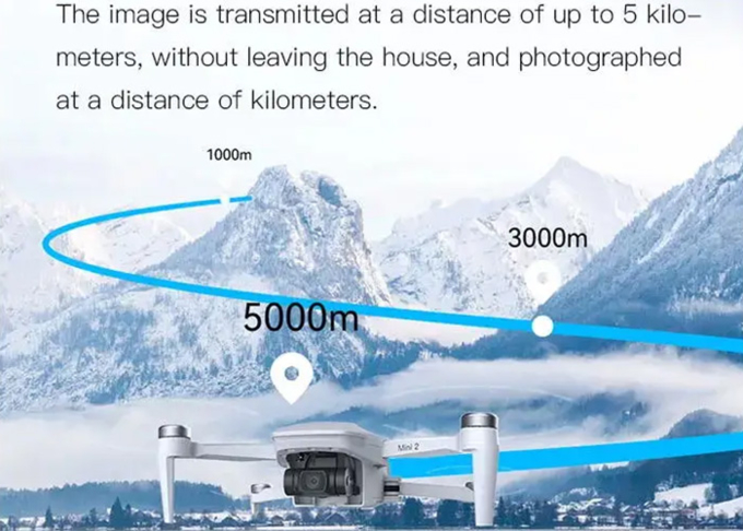
Accessories & Parts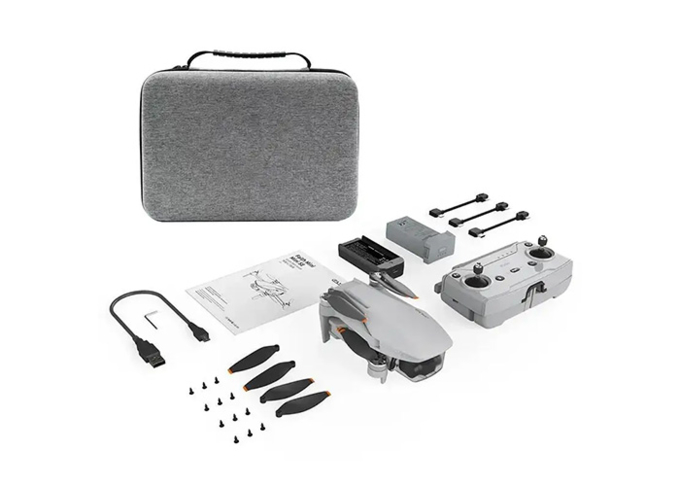

Long Distance Heavy Lifting Drone Heavy Payload Drone With 29 mins Full Load Flight Time HK-DF816D

High Capacity 5 Km Range Remote Control RC Drone With 3 Axis Gimbal Camera HK-DF816D

Faith2 SE Aerial Survey Drone Foldable Remote Control Drone With Camera

Aerial Photogrammetry Drone Foldable 3D Scanning Drone For Topographic Survey

Mapping And Surveying Drones , Professional Drones For Surveying

High Range Aerial Survey Drone 17m/s Foldable 2 Axis Gimbal Drone HK-DF809G

3D Aerial Photogrammetry Drone / Land Mapping Drone With 3 Axis Gimbal

5m/s Aerial Remote Sensing Drone With Thermal Imaging Camera

Custom Aerial Survey Drone Advanced Aerial Surveillance Drone For Surveying And Mapping

Foldable Aerial Survey Drone Two Axis Gimbal Construction Site Drone Aerial Photogrammetry

Aerial Inspection Drone Surveying And Mapping 4m/s Professional Photography Drones

Folding Remote Control RC Drone Rechargeable With Strong Flight Performance HK-DF816D
Long Distance Heavy Lifting Drone Heavy Payload Drone With 29 mins Full Load Flight Time HK-DF816D

3 Axis Gimbal Load Bearing Drone 4m/s Cargo Carrying Drone Foldable

Faith Mini 3D Survey Drone 1080P 10km UAV Mapping Drone With Strong Flight Performance

Foldable Remote Sensing Drone 4m/S Professional Drone With HD Camera HK-DF812E
1 Sold
