


Not include shipping cost.
LINK-PP LPJ1075-1BHNL 100% Cross RTA-110AHQ1A UDE
United States
Carrier
CostDelivery TimeTracking
DHL
$ 31.97 3-7 daysAvailable
Fedex IP
$ 44.07 3-7 daysAvailable
DHL自定义
$ 51.37 3-7 daysAvailable
UPS Express Saver
$ 94.28 3-7 daysAvailable
Foldable Aerial Survey Drone Two Axis Gimbal Construction Site Drone Aerial Photogrammetry
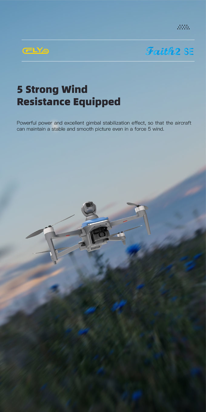
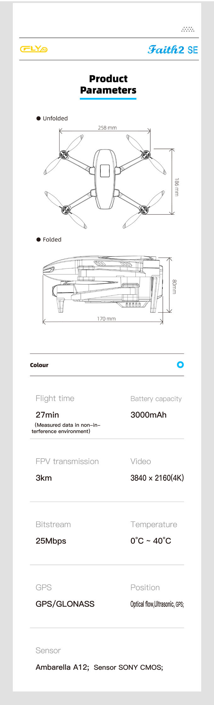
Aerial Survey Drone is a professional aerial measurement and photogrammetry drone which is designed to provide accurate and reliable aerial survey data for efficient and cost-effective survey applications. It is equipped with satellite positioning systems such as GPS/GLONASS and features a maximum ascend speed of 4m/s, take off weight of about 3178g, wheelbase for foldable operation, and global 4G image transmission with unlimited distance for extended aerial imaging. The Aerial Survey Drone is a great choice for surveying applications, mapping, and other aerial measurement tasks.
| Attributes | Technical Parameters |
|---|---|
| Flight Control | Compatible with Mavlink Protocol Flight Control |
| 4G Extended Image Transmission | Global 4G Image Transmission, Unlimited Distance |
| Wheelbase | Foldable |
| Battery | 3000mAh |
| Maximum Speed | 17m/s |
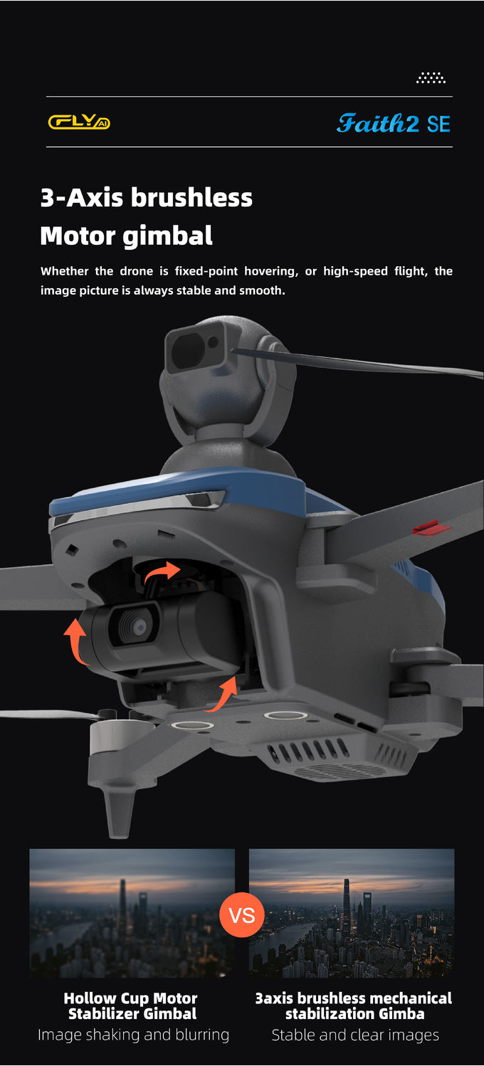
| Gimbal | Two Axis |
| Screen Type | LCD |
| Operating Temperature Range | -5-40℃ |
| Take Off Weight | About 3178g |
| Flight Time | 40mins(no Load),29mins(full Load) |
Aerial Survey Drone, with model number Faith2 SE, is a reliable, lightweight drone with a maximum ascend speed of 4m/s and a take off weight of about 3178g. It is made in China and offered at negotiable prices with a minimum order quantity of 1 pcs. Packaged in standard packages, the drone can be delivered within 3-7 work days with payment terms including L/C, D/A, D/P, T/T, and Western Union. The supply ability is up to 100,000 pcs per month. The drone is equipped with a 3000mAh battery, two-axis gimbal and a foldable wheelbase.
The Aerial Survey Drone is used for various applications, such as aerial mapping, aerial measurement and aerial monitoring. It has a high-quality camera that can capture HD images and videos with precise detail. It also has a powerful navigation system that can provide accurate data and real-time information. The drone is ideal for surveying, monitoring and measuring large areas, such as construction sites, farms, and forests. It can save time and money by reducing the need for manual surveying and inspection.
The Aerial Survey Drone is an efficient and cost-effective tool for surveying, mapping, measuring and monitoring. With its high-quality camera, powerful navigation system and foldable wheelbase, it can provide accurate data and real-time information in a fast, easy and safe manner. It is an ideal choice for aerial mapping, aerial measurement, and aerial monitoring projects.


Faith Mini 3D Mapping Drones Land Surveying Drone For Aerial Mapping
1 Sold

JPEG Photo Remote Sensing Drone 3 Axis Gimbal With Thermal Imaging Technology
2 Sold

2100mAh 3D Mapping Drones Versatile Imaging Topographic Mapping Drone

Aerial Photogrammetry Drone Foldable 3D Scanning Drone For Topographic Survey

white Custom 3 Axis Gimbal Camera Drone For Construction Industry HK-DF846D

Foldable Remote Sensing Drone 4m/S Professional Drone With HD Camera HK-DF812E
1 Sold

1080P 10km 3D Mapping Drones Foldable Land Mapping Drone Customized

Mapping And Surveying Drones , Professional Drones For Surveying

Faith Mini 3D Survey Drone 1080P 10km UAV Mapping Drone With Strong Flight Performance

Two Axis Aerial Imaging Drone 1080P 10km Construction Monitoring Drone HK-DF809G

5m/s Aerial Remote Sensing Drone With Thermal Imaging Camera

Folding Remote Control RC Drone Rechargeable With Strong Flight Performance HK-DF816D

Powerful Heavy Load Carrying Drone 1080P 10km High Performance Drone

Faith2 SE Aerial Survey Drone Foldable Remote Control Drone With Camera

Long Distance Heavy Lifting Drone Heavy Payload Drone With 29 mins Full Load Flight Time HK-DF816D

High Range Aerial Survey Drone 17m/s Foldable 2 Axis Gimbal Drone HK-DF809G
