


Not include shipping cost.
LINK-PP LPJ1075-1BHNL 100% Cross RTA-110AHQ1A UDE
United States
Carrier
CostDelivery TimeTracking
DHL
$ 31.97 3-7 daysAvailable
Fedex IP
$ 44.07 3-7 daysAvailable
DHL自定义
$ 51.37 3-7 daysAvailable
UPS Express Saver
$ 94.28 3-7 daysAvailable
white Custom 3 Axis Gimbal Camera Drone For Construction Industry HK-DF846D
Specification
| 1 | Aircraft | Faith mini | ||||
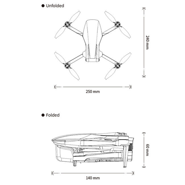
| Size | Unfold: 165 X 188 X 59 mm ( L*W*H) Fold:142 X 84 X 57 mm( L*W*H) | |||||
| Wheelbase | 218 mm | |||||
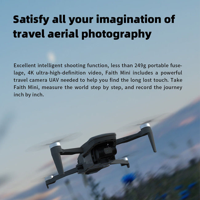
| Weight (Battery & Propellers Included) | under 250g | |||||
| Max Ascent Speed | 4m/s(sport mode) 2.5m/s(Normal mode,can set from 1~3m/s) 3.5m/s(RTH mode) | |||||
| Max Descent Speed | 3m/s(sport mode) 2m/s(Normal mode,can set from 1~3m/s) 3m/s(RTH mode) | |||||
| Max Speed | 14m/s(sport mode) 8m/s(Normal mode,can set from 2~ 10m/s) 12m/s(RTH mode) | |||||
| Max Service Ceiling Above Sea Level | 4000 m | |||||
| Max Flight Time | 26 mins | |||||
| Operating Temperature Range | 0°C~40°C | |||||
| Satellite Positioning Systems | GPS/GLONASS | |||||
| Hover Accuracy Range | vertical: +/- 0.5 m horizonal: +/- 1.5m ± 0.3 m( optical flow system works) | |||||
| Operating Frequency | 2.4GHz | |||||
| Maximum flight height | 120m ,maximum 500m (set on app) | |||||
| 2 Optical flow system | ||||||
| Optical flow system | yes | |||||
| Operating Environment | Surface with clear pattern and adequate lighting (lux > 15) | |||||
| Velocity Range | ≤1.5 m/s at 6.6 ft (2 m) above ground | |||||
| Altitude Range | 0.02~4m | |||||
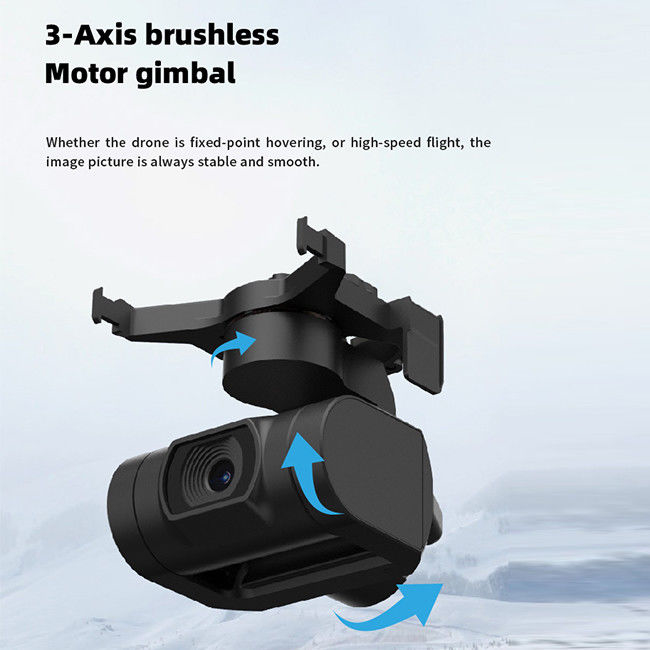
| 3 3-axis gimbal | ||||||
| Stabilization | 3-axis(pitch:+30/-120° , roll:± 30° ,course:±30° ) | |||||
| Controllable Range | pitch:-90°~ 15° | |||||
| Jitter Amount | ±0.01° | |||||
| 4 Camera | ||||||
| Sensor | SONY CMOS; | |||||
| Image Size | 3840*2160(8MP) | |||||
| Video Recording Resolution | 3840×2160(4K) 15FPS ,2716×1524(2.7k)25FPS | |||||
| Maximum Video Bit | 25 Mbps | |||||
| Supported File Systems | FAT32(<=32GB) /exFAT(>32GB) | |||||
| Photo | JPEG /JPEG | |||||
| Video | MP4 | |||||
| Supported SD Cards | Micro SD ™ Max capacity:128GB. UHS-I Speed Grade 3 rating required | |||||
| Operating Temperature Range | 0°C~40°C | |||||
| 5 Battery | ||||||
| Capacity | 2100mAh | |||||
| Voltage | 7.7V | |||||
| Battery Type | LiPo 2S | |||||
| Energy | 16. 17 Wh | |||||
| Net Weight | 80 g | |||||
| Charging Temperature Range | 0°C~40°C | |||||
| Max charging power | 16W | |||||
| charge time | <2.5h(with 5V 2A adapter) | |||||
| 6 APP | ||||||
| Mobile App | C-Fly GO | |||||
| Live View Quality | 720p, automatically change definition based on condition | |||||
| Maximum FPV transmission distance | 5000m | |||||
| Aerial photography mode | drone,rocket, circle,helix | |||||
| Required Operating Systems | Android 6.0 above, IOS 10.0above | |||||
| 7 Charger | ||||||
| Input | 5 V 2A(recommend) | |||||
| Output | 4.4V 1A×2 | |||||
| Power | 10 W | |||||
| 8 Remote Controller | ||||||
| Operating Frequency | 5.8GHz | |||||
| Max Transmission Distance | 3000m(FCC) | |||||
| Operating Temperature Range | 0°C~40°C | |||||
| Operating Current/Voltage | 700mA/3.7V | |||||
| Supported Mobile Device Size | Thickness Supported:6.5-8.5mm | |||||
| Battery capacity(built-in) | 3.7v 3000 mAh,2.5hours for usage time(depend on different phone) | |||||
| Battery type | LiPo 18650 | |||||
| Battery power | 9.62 Wh | |||||
| Charge | USB | |||||
| Maximum charge power | 10W | |||||
| charge time | < 2.5h(with 5V 2A adapter) | |||||
Description
3D Mapping Drone, also known as a UAV (Unmanned Aerial Vehicle) or UAS (Unmanned Aerial System) for 3D mapping, is an unmanned aircraft equipped with specialized sensors and cameras used to capture aerial imagery and data for creating three-dimensional maps and models of the terrain or objects below. These drones are specifically designed for mapping, surveying, and creating detailed 3D representations of various environments.
Features
Applications

Mapping And Surveying Drones , Professional Drones For Surveying

Custom Aerial Survey Drone Advanced Aerial Surveillance Drone For Surveying And Mapping

1080P 10km Remote Sensing Drones Agriculture / Crop Monitoring Drone
1 Sold

Powerful Heavy Load Carrying Drone 1080P 10km High Performance Drone

High Range Aerial Survey Drone 17m/s Foldable 2 Axis Gimbal Drone HK-DF809G

3D Aerial Photogrammetry Drone / Land Mapping Drone With 3 Axis Gimbal

1080p 4k Ultra HD Camera Drone Industrial Drones For Lifting HK-Faith Mini

5m/s Aerial Remote Sensing Drone With Thermal Imaging Camera

2100mAh 3D Mapping Drones Versatile Imaging Topographic Mapping Drone

Two Axis Aerial Imaging Drone 1080P 10km Construction Monitoring Drone HK-DF809G

Aerial Photogrammetry Drone Foldable 3D Scanning Drone For Topographic Survey

4m/S 3D Mapping Drones For Surveying Land 3840*2160 Image Size

Faith2 SE Aerial Survey Drone Foldable Remote Control Drone With Camera

1080P 10km 3D Mapping Drones Foldable Land Mapping Drone Customized

Aerial Inspection Drone Surveying And Mapping 4m/s Professional Photography Drones

Long Distance Heavy Lifting Drone Heavy Payload Drone With 29 mins Full Load Flight Time HK-DF816D
