


Not include shipping cost.
LINK-PP LPJ1075-1BHNL 100% Cross RTA-110AHQ1A UDE
United States
Carrier
CostDelivery TimeTracking
DHL
$ 31.97 3-7 daysAvailable
Fedex IP
$ 44.07 3-7 daysAvailable
DHL自定义
$ 51.37 3-7 daysAvailable
UPS Express Saver
$ 94.28 3-7 daysAvailable
Aerial Inspection Drone Surveying And Mapping 4m/s Professional Photography Drones
Aerial Survey Drone is the perfect tool for aerial data collection, aerial imaging and aerial photogrammetry. With maximum ascend speed of 4m/s and two axis gimbal, it can take crystal clear 1080P images within 10km distance. Moreover, it supports global 4G image transmission, ensuring unlimited distance transmission of images. Its flight time of 40 minutes (no load) and 29 minutes (full load) allows for long and uninterrupted aerial survey and imaging.
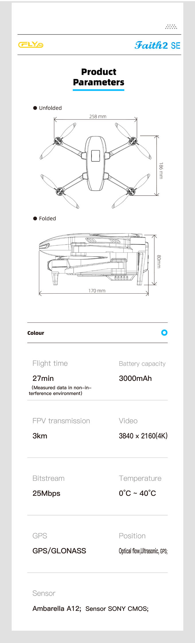
| Parameters | Aerial Survey Drone |
|---|---|
| Flight Time (no Load) | 40mins |
| Flight Time (full Load) | 29mins |
| Max Service Ceiling Above Sea Level | 4000m |
| Maximum Speed | 17m/s |
| 4G Extended Image Transmission | Global 4G Image Transmission, Unlimited Distance |
| Wheelbase | Foldable |
| Maximum Distance | 1080P 10km |
| Satellite Positioning Systems | GPS/GLONASS |
| Flight Control | Compatible With Mavlink Protocol Flight Control |
| Maximum Decsend Speed | 3m/s |
| Operating Temperature Range | -5-40℃ |
Aerial Survey Drone, with its model number Faith2 SE, is a reliable drone produced in China with a minimum order quantity of 1 pcs. It has a foldable wheelbase and a maximum service ceiling of 4000m above sea level, plus a maximum ascend speed of 4m/s. It is equipped with global 4G image transmission, allowing unlimited distance transmission of 1080P image, with a maximum distance of 10km. It is widely used in aerial photogrammetry and observation, aerial mapping and survey, and is available at a negotiable price. The package can be customized in accordance with the customer's requirement, and the delivery time is within 3-7 work days. The payment terms are flexible, including L/C, D/A, D/P, T/T, Western Union, etc. The supply ability is up to 100,000 pcs per month.
Q: What is the model number of Aerial Survey Drone?
A: The model number of Aerial Survey Drone is Faith2 SE.
Q: Where is Aerial Survey Drone from?
A: Aerial Survey Drone is from China.
Q: What's the minimum order quantity of Aerial Survey Drone?
A: The minimum order quantity of Aerial Survey Drone is 1 Pcs.
Q: What is the price of Aerial Survey Drone?
A: The price of Aerial Survey Drone is Negotiatial.
Q: What is the packaging details of Aerial Survey Drone?
A: The packaging details of Aerial Survey Drone is Standard Packages.
Q: What is the delivery time of Aerial Survey Drone?
A: The delivery time of Aerial Survey Drone is 3-7 work days.
Q: What are the payment terms of Aerial Survey Drone?
A: The payment terms of Aerial Survey Drone are L/C, D/A, D/P, T/T, Western Union.
Q: How many Aerial Survey Drone can be supplied per month?
A: 100,000 pcs Aerial Survey Drone can be supplied per month.

Foldable Remote Sensing Drone 4m/S Professional Drone With HD Camera HK-DF812E
1 Sold

white Custom 3 Axis Gimbal Camera Drone For Construction Industry HK-DF846D

Foldable 3D Mapping Drones For Topographic Mapping 3840*2160 HK-DF8166D

Powerful Heavy Load Carrying Drone 1080P 10km High Performance Drone

JPEG Photo Remote Sensing Drone 3 Axis Gimbal With Thermal Imaging Technology
2 Sold

1 Sold

Foldable Aerial Survey Drone Two Axis Gimbal Construction Site Drone Aerial Photogrammetry

Two Axis Aerial Imaging Drone 1080P 10km Construction Monitoring Drone HK-DF809G

3 Axis Gimbal Drone High Performance For Fire Rescue Power Patrol HK-DF816D

Long Distance Heavy Lifting Drone Heavy Payload Drone With 29 mins Full Load Flight Time HK-DF816D

Aerial Photogrammetry Drone Foldable 3D Scanning Drone For Topographic Survey

Precision Agriculture Drone 1080P 10km Environmental Monitoring Drone Remote Sensing

1080P 10km Remote Sensing Drones Agriculture / Crop Monitoring Drone
1 Sold
Long Distance Heavy Lifting Drone Heavy Payload Drone With 29 mins Full Load Flight Time HK-DF816D

3 Axis Gimbal Load Bearing Drone 4m/s Cargo Carrying Drone Foldable

Faith Mini 3D Mapping Drones Land Surveying Drone For Aerial Mapping
1 Sold
