


Not include shipping cost.
LINK-PP LPJ1075-1BHNL 100% Cross RTA-110AHQ1A UDE
United States
Carrier
CostDelivery TimeTracking
DHL
$ 31.97 3-7 daysAvailable
Fedex IP
$ 44.07 3-7 daysAvailable
DHL自定义
$ 51.37 3-7 daysAvailable
UPS Express Saver
$ 94.28 3-7 daysAvailable
1080P 10km Remote Sensing Drones Agriculture / Crop Monitoring Drone
Specification
| 1 | Aircraft | Faith 2 Pro | Note | ||
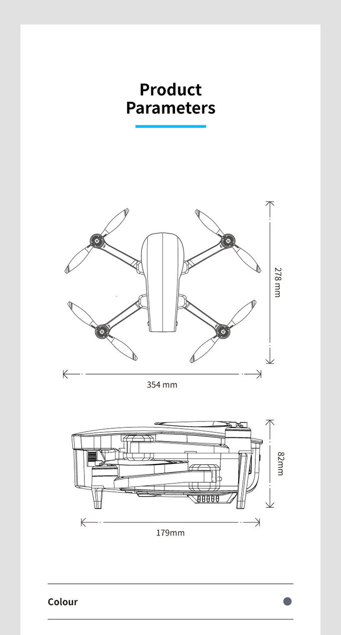
| Size | Unfold: 191 X 262 X 107 mm ( L*W*H) Fold: 179X 108 X 74 mm( L*W*H) | ||||
| Wheelbase | 280 mm | ||||
| Weight (Battery & Propellers Included) | 562g | ||||
| Max Ascent Speed | 4m/s(sport mode) 3m/s(Normal mode) | ||||
| Max Descent Speed | 3m/s(sport mode) 2m/s(Normal mode) | ||||
| Max Speed | 14m/s(sport mode) 10m/s(Normal mode) | ||||
| Max Service Ceiling Above Sea Level | 4000 m | ||||
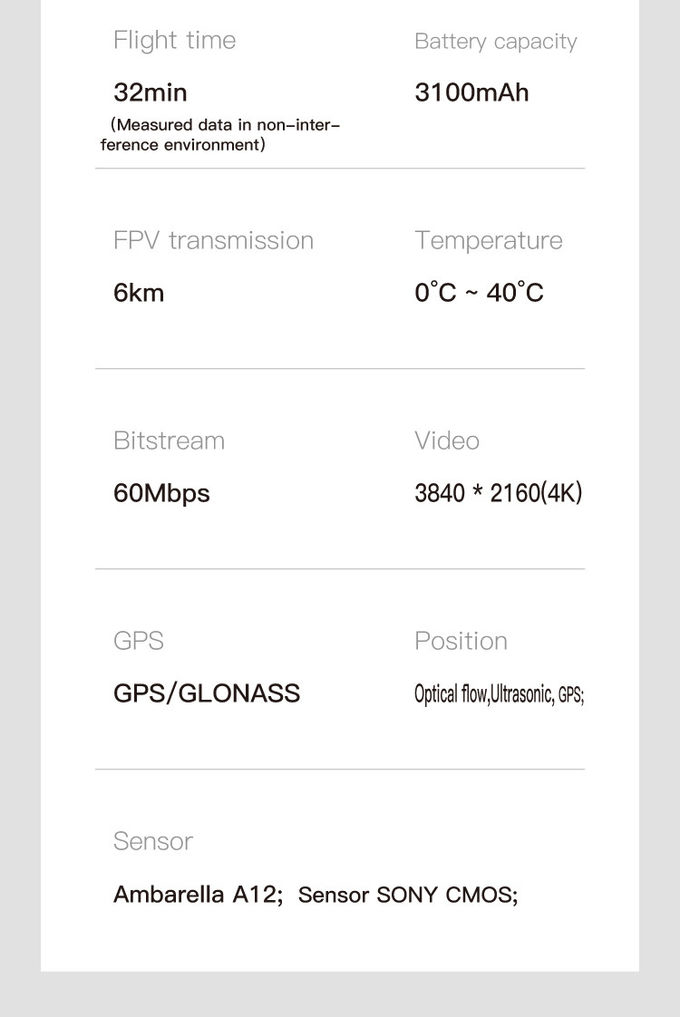
| Max Flight Time | 32 mins | ||||
| Operating Temperature Range | 0°C~40°C | ||||
| Satellite Positioning Systems | GPS/GLONASS | ||||
| Hover Accuracy Range | vertical: +/- 0.5 m ± 0.2 m( ultrasonic system,optical flow system works) horizonal: +/- 1.5m ± 0.3 m( ultrasonic system,optical flow system works) | ||||
| Operating Frequency | 2.4GHz | ||||
| Maximum flight height | 120m ,maximum 800m (set on app) | ||||
| 2 Optical flow system | |||||
| Optical flow system | yes | ||||
| Operating Environment | Surface with clear pattern and adequate lighting (lux > 15) | ||||
| Velocity Range | ≤1.5 m/s at 6.6 ft (2 m) above ground | ||||
| Altitude Range | 0.5~5m | ||||
| 3 Ultrasonic altitude system | |||||
| Ultrasonic altitude system | yes | ||||
| Operating Environment | except for surface of water or ground of absorbing material (such as thick carpet) | ||||
| Velocity Range | ≤ 3m/s | ||||
| Altitude Range | 0.2~4.5m | ||||
| 4 Obstacle avoidance | |||||
| Obstacle avoidance type | 2-axis laser | ||||
| Obstacle avoidance direction | 540° ,top,left,right,front,back | ||||
| Maximum detection range | 20m | ||||
| Maximum obstacle avoidance speed | 10m/s | ||||
| 5 3-axis gimbal | |||||
| Stabilization | 3-axis(pitch:+30/-120° , roll:± 30° ,course:±30° ) | ||||
| Controllable Range | pitch:-90°~20° | ||||
| Jitter Amount | 0.01° | ||||
| 6 Camera | |||||
| Sensor | SONY CMOS; | ||||
| Image Size | 5180*3840(20MP) | ||||
| Video Recording Resolution | 3860*2140(4K),30FPS | ||||
| Supported File Systems | FAT32(<=32GB) /exFAT(>32GB) | ||||
| Shooting mode | single shot ,delay shoot | ||||
| Video | MP4 | ||||
| Supported SD Cards | Micro SD ™ Max capacity:128GB. UHS-I Speed Grade 3 rating required | ||||
| Operating Temperature Range | 0°C~40°C | ||||
| 7 Battery | |||||
| Capacity | 3100mAh | ||||
| Voltage | 11.4V | ||||
| Battery Type | LiPo 3S | ||||
| Energy | 35.34 Wh | ||||
| Net Weight | 196 g | ||||
| Charging Temperature Range | 0°C~40°C | ||||
| Max charging power | 35 W | ||||
| charge time | <5h(with 5V 2A adapter) | ||||
| 8 APP | |||||
| Mobile App | C-Fly 2 | ||||
| Live View Quality | 1080p,automatically change definition based on condition | ||||
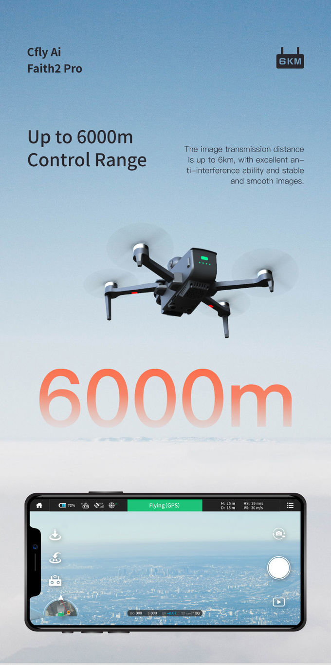
| Maximum FPV transmission distance | 6000m | ||||
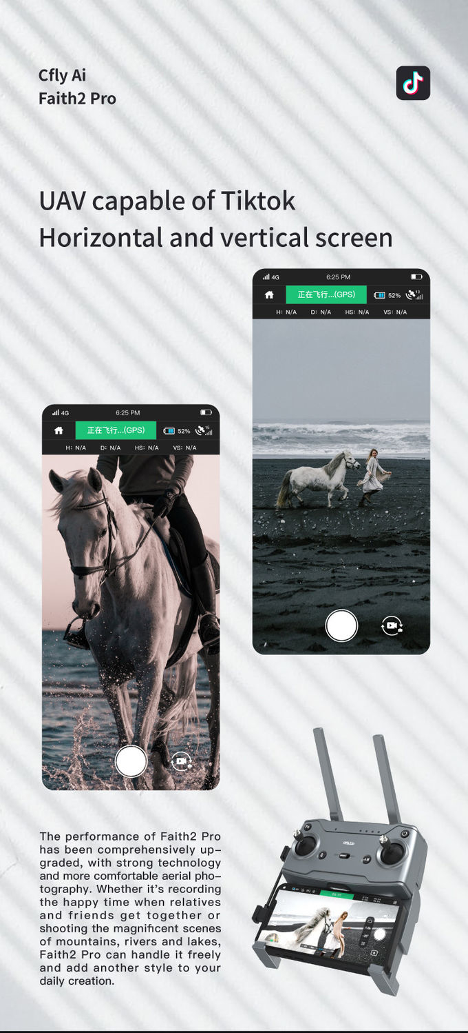
| Aerial photography mode | dronie,rocket,circle,helix,boomerang,delay,live show,Vertical screen ,Visual follow | ||||
| Required Operating Systems | Andrio 6.0 above ,IOS 10.0above | ||||
| 9 Charger | |||||
| Input | 5 V 2A(recommend) | ||||
| Output | 4.35V 0.7A×3 | ||||
| 10 Remote Controller | |||||
| Operating Frequency | 2.4GHz | ||||
| Max Transmission Distance | 6000m(CE) | ||||
| Operating Temperature Range | 0°C~40°C | ||||
| Operating Current/Voltage | 700mA/3.7V | ||||
| Supported Mobile Device Size | Thickness Supported:6.5-8.5mm | ||||
| Battery capacity(built-in) | 3.7v 3000 mAh | ||||
| Battery type | LiPo 18650 | ||||
| Battery power | 11. 1 Wh | ||||
| Charge | USB | ||||
| Maximum charge power | 10W | ||||
| charge time | < 2.5h(with 5V 2A adapter) | ||||
Description
Remote Sensing Drone, also known as a UAV (Unmanned Aerial Vehicle) or UAS (Unmanned Aerial System) for remote sensing, is an unmanned aircraft equipped with specialized sensors and cameras used to collect data and imagery from a distance for various scientific, environmental, and mapping applications. These drones are specifically designed for remote sensing purposes, allowing for the collection of valuable information about the Earth's surface, atmosphere, and environment.
Features
Applications
Environmental Monitoring: Remote Sensing Drones are used for monitoring environmental conditions and changes. They can collect data on vegetation health, land use and land cover, water quality, coastal erosion, and forest fires. This information aids in assessing the impact of human activities and natural processes on the environment.
Agriculture and Crop Monitoring: These drones have applications in agriculture for crop monitoring, yield estimation, and precision farming. They can capture multispectral or thermal imagery to analyze plant health, detect stress or diseases, optimize irrigation, and improve crop management practices.
Forestry and Natural Resource Management: Remote Sensing Drones are employed in forestry and natural resource management. They can assess forest health, monitor tree growth, detect invasive species, estimate biomass, and map deforestation or forest degradation. This information helps in sustainable forest management and conservation effort


Foldable 3D Mapping Drones For Topographic Mapping 3840*2160 HK-DF8166D

Custom Aerial Survey Drone Advanced Aerial Surveillance Drone For Surveying And Mapping

Foldable Remote Sensing Drone 4m/S Professional Drone With HD Camera HK-DF812E
1 Sold

4m/S 3D Mapping Drones For Surveying Land 3840*2160 Image Size

3 Axis Gimbal Load Bearing Drone 4m/s Cargo Carrying Drone Foldable

Mapping And Surveying Drones , Professional Drones For Surveying

1 Sold

Faith Mini 3D Mapping Drones Land Surveying Drone For Aerial Mapping
1 Sold

1080P 10km 3D Mapping Drones Foldable Land Mapping Drone Customized

Aerial Photogrammetry Drone Foldable 3D Scanning Drone For Topographic Survey

Folding Remote Control RC Drone Rechargeable With Strong Flight Performance HK-DF816D

1080p 4k Ultra HD Camera Drone Industrial Drones For Lifting HK-Faith Mini

Two Axis Aerial Imaging Drone 1080P 10km Construction Monitoring Drone HK-DF809G

5m/s Aerial Remote Sensing Drone With Thermal Imaging Camera

3D Aerial Photogrammetry Drone / Land Mapping Drone With 3 Axis Gimbal

Aerial 3D Mapping Drones Foldable for Land Surveying
