


Not include shipping cost.
LINK-PP LPJ1075-1BHNL 100% Cross RTA-110AHQ1A UDE
United States
Carrier
CostDelivery TimeTracking
DHL
$ 31.97 3-7 daysAvailable
Fedex IP
$ 44.07 3-7 daysAvailable
DHL自定义
$ 51.37 3-7 daysAvailable
UPS Express Saver
$ 94.28 3-7 daysAvailable
Mapping And Surveying Drones , Professional Drones For Surveying
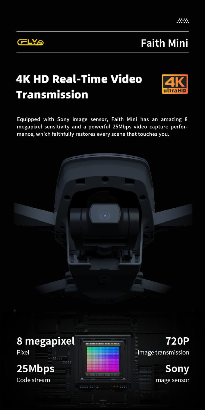
3D Mapping Drones are remotely-operated-UAV-mapping machines designed for autonomous-drone-surveying operations. With a 600mm wheelbase and a foldable design, 3D Mapping Drones offer high mobility and compactness. They come equipped with a 3-axis gimbal, as well as GPS/GLONASS satellite positioning systems for accurate positioning and navigation. Global 4G image transmission allows for unlimited distance image transmission, and users can enjoy 1080P high-definition images up to 10km away. 3D Mapping Drones are versatile unmanned-aerial-vehicles-mapping solutions that can be used in a variety of surveying scenarios.
| Features | Specifications |
|---|---|
| Battery | 2100mAh |
| Satellite Positioning Systems | GPS/GLONASS |
| Maximum Distance | 1080P 10km |
| Max Service Ceiling Above Sea Level | 5000m |
| Maximum Ascend Speed | 5m/s |
| Gimbal | 3-axis |
| Photo | JPEG |
| Operating Temperature Range | -5-40℃ |
| Flight Time | 40mins(no Load),29mins(full Load) |
| Flight Control | Compatible With Mavlink Protocol Flight Control |
| Remotely-Operated-UAV-Mapping | Yes |
| Autonomous-Drone-Surveying | Yes |
3D Mapping Drones, which model Faith mini, is made in China with a minimum order quantity of 1 Pcs and a negotiable price. It is packaged in standard packages and can be delivered within 3-7 work days after payment. The payment terms include L/C, D/A, D/P, T/T, Western Union, and the supply ability is 100,000 pcs per month. It has a satellite positioning systems of GPS/GLONASS, a max service ceiling above sea level of 5000m, a flight time of 40mins(no load) and 29mins(full load), and an operating temperature range of -5-40℃. Its flight control is compatible with Mavlink Protocol Flight Control.
3D Mapping Drones has a variety of applications and scenarios. It is widely used in Geographic-Information-System-Drones, which helps to capture and analyze the data of geographic features such as roads, buildings, rivers and more. It can also be used in High-Resolution-Surveying-Drones for measuring and analyzing the terrain to generate survey maps. In addition, it can be used for Robotic-Mapping-Aircrafts, which can be used in aerial photogrammetry, topography, and 3D modeling.
We offer high-resolution surveying drones, topographical mapping drones, and robotic mapping aircrafts. Our Faith mini 3D mapping drones are the perfect solution for any mapping project. With a wheelbase of 600mm, they are foldable for easy storage and portability. The maximum distance is 1080P 10km, and the flight time is 40mins(no load) and 29mins (full load). With GPS/GLONASS satellite positioning systems, the Faith mini can take high-quality photos in JPEG format. The minimum order quantity is 1 pc, and the price is negotiable. Standard packages are available for delivery, with 3-7 work days. Payment options include L/C, D/A, D/P, T/T, and Western Union. Our supply ability is 100,000 pcs per month.

Faith Mini 3D Survey Drone 1080P 10km UAV Mapping Drone With Strong Flight Performance

Precision Agriculture Drone 1080P 10km Environmental Monitoring Drone Remote Sensing

Powerful Heavy Load Carrying Drone 1080P 10km High Performance Drone

Long Distance Heavy Lifting Drone Heavy Payload Drone With 29 mins Full Load Flight Time HK-DF816D

Aerial 3D Mapping Drones Foldable for Land Surveying

1080P 10km Remote Sensing Drones Agriculture / Crop Monitoring Drone
1 Sold

4m/S 3D Mapping Drones For Surveying Land 3840*2160 Image Size

High Capacity 5 Km Range Remote Control RC Drone With 3 Axis Gimbal Camera HK-DF816D

Aerial Inspection Drone Surveying And Mapping 4m/s Professional Photography Drones

Faith Mini 3D Mapping Drones Land Surveying Drone For Aerial Mapping
1 Sold

white Custom 3 Axis Gimbal Camera Drone For Construction Industry HK-DF846D

Aerial Photogrammetry Drone Foldable 3D Scanning Drone For Topographic Survey

Two Axis Aerial Imaging Drone 1080P 10km Construction Monitoring Drone HK-DF809G

Durable Remote Sensing Drone 3 Axis Gimbal Drones For Environmental Monitoring

3 Axis Gimbal Drone High Performance For Fire Rescue Power Patrol HK-DF816D

1080p 4k Ultra HD Camera Drone Industrial Drones For Lifting HK-Faith Mini
