


Not include shipping cost.
LINK-PP LPJ1075-1BHNL 100% Cross RTA-110AHQ1A UDE
United States
Carrier
CostDelivery TimeTracking
DHL
$ 31.97 3-7 daysAvailable
Fedex IP
$ 44.07 3-7 daysAvailable
DHL自定义
$ 51.37 3-7 daysAvailable
UPS Express Saver
$ 94.28 3-7 daysAvailable
Durable Remote Sensing Drone 3 Axis Gimbal Drones For Environmental Monitoring
Remote Sensing Drones are the perfect robotic aerial system that provides autonomous aerial vehicle solutions for a variety of applications. Designed to fly autonomously in various conditions, they make the perfect tool for capturing highly detailed aerial images. Equipped with a 3-axis gimbal and satellite positioning systems, such as GPS and GLONASS, Remote Sensing Drones provide highly accurate navigation and stability. With an image size of 3840*2160, the resulting photos taken by the drones are of the highest quality in JPEG format. In addition, the drone can reach a maximum service ceiling of 4000 M above sea level, making it a great tool for capturing aerial photos and videos from great heights.
| Parameter | Detail |
|---|---|
| Flight Control | Compatible with Mavlink Protocol Flight Control |
| Satellite Positioning Systems | GPS/GLONASS |
| Photo | JPEG |
| Wheelbase | 600mm, foldable |
| Battery | 3100mAh |
| Flight Time | 40mins (no load), 29mins (full load) |
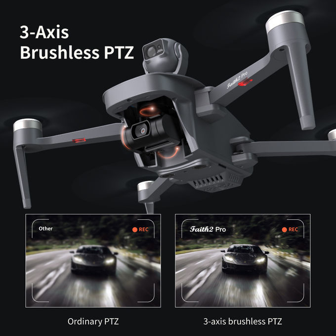
| Gimbal | 3-axis |
| Image Size | 3840*2160 |
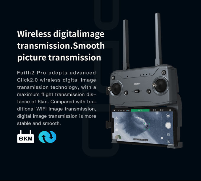
| 4G Extended Image Transmission | Global 4G Image Transmission, Unlimited Distance |
| Max Service Ceiling Above Sea Level | 4000 M |
The Faith 2 Pro Remote Sensing Drone is an autonomous aerial system designed to provide high-quality, real-time airborne surveillance for both commercial and private purposes. It is equipped with advanced remote sensing technology, GPS/GLONASS satellite positioning systems, a 3-axis gimbal, and a maximum descend speed of 4m/s. Its image size is 3840*2160 and its wheelbase is 600mm, making it foldable for easy storage.
The Faith 2 Pro Remote Sensing Drone is the perfect solution for a variety of unmanned surveillance needs, from aerial photography and mapping to environmental monitoring and search and rescue operations. With its powerful features and high-performance capabilities, it is capable of providing reliable and accurate data, making it an invaluable tool for businesses and organizations.
The Faith 2 Pro Remote Sensing Drone is available for purchase with a minimum order quantity of 1 Pcs. Prices are negotiable and delivery time is 3-7 work days. Payment is accepted via L/C, D/A, D/P, T/T, and Western Union. The product is packaged in standard packages and the supply ability is 100,000 pcs per month.
Our Remote Sensing Drone is an Autonomous Aerial System for Unmanned Surveillance and Unmanned Aerial Vehicle. With a maximum image size of 3840x2160, this drone is capable of Global 4G Image Transmission and Unlimited Distance. It also has a 3100mAh battery and an operating temperature range of -5-40℃. This drone is available with a minimum order quantity of 1 pcs and a supply ability of 100,000 pcs per month. The price is negotiable and it is packed in standard packages. Delivery time is 3-7 work days and the payment terms are L/C, D/A, D/P, T/T, Western Union.
Q: Are you a manufacturer or trade company?
A: We are the manufacturer.
Q: Do you accept customization?
A: Yes, we accept customization both on software & hardware and logo branding, color boxes, as well as packaging.
Q: What is your warranty policy?
A: One-year warranty, replacement, or repair services shall be provided under non-artificial quality issues.
Q: What's your MOQ?
A: Our MOQ is 1000pcs, trial orders, and samples are also available.
Q: How about the lead time and delivery time?
A: The stocked sample shall be sent out within 1-3 days after payment is received if the model is stocked
The lead time for mass quantities will be sent out within 30-35 days.
Delivery time : 3-7 days to arrive at destination after delivery if sent by international express like DHL, UPS, FedEx, etc.
Sea Transportation: 25-30 days after sailing
Q: How long does it take for the Infrastructure Inspection Drone to be delivered?
A: The Infrastructure Inspection Drone will be delivered within 3-7 work days.
Q: Do you provide SKD service?
A: Yes, we can do SKD orders, if your company can assemble yourself, the MOQ is 1000pcs.
Q: What is the Supply Ability for the Infrastructure Inspection Drone?
A: The Supply Ability for the Infrastructure Inspection Drone is 100,000 pcs per month.
Q: Where are the drones shipped from?
A: We send drones from our Shenzhen factory, or we can send them from Vietnam and the Philippines.
Q: Do you provide any value-added services for particular purposes?
A: We can dispatch our professional engineers to your company for drone assembly if your order quantity reaches our requirements.

Foldable Remote Sensing Drone 4m/S Professional Drone With HD Camera HK-DF812E
1 Sold

Foldable Aerial Survey Drone Two Axis Gimbal Construction Site Drone Aerial Photogrammetry

Folding Remote Control RC Drone Rechargeable With Strong Flight Performance HK-DF816D

Custom Aerial Survey Drone Advanced Aerial Surveillance Drone For Surveying And Mapping

4m/S 3D Mapping Drones For Surveying Land 3840*2160 Image Size

Powerful Heavy Load Carrying Drone 1080P 10km High Performance Drone

Aerial Photogrammetry Drone Foldable 3D Scanning Drone For Topographic Survey

3 Axis Gimbal Drone High Performance For Fire Rescue Power Patrol HK-DF816D

Long Distance Heavy Lifting Drone Heavy Payload Drone With 29 mins Full Load Flight Time HK-DF816D

JPEG Photo Remote Sensing Drone 3 Axis Gimbal With Thermal Imaging Technology
2 Sold

Faith2 SE Aerial Survey Drone Foldable Remote Control Drone With Camera

2100mAh 3D Mapping Drones Versatile Imaging Topographic Mapping Drone

Aerial Inspection Drone Surveying And Mapping 4m/s Professional Photography Drones
Long Distance Heavy Lifting Drone Heavy Payload Drone With 29 mins Full Load Flight Time HK-DF816D

white Custom 3 Axis Gimbal Camera Drone For Construction Industry HK-DF846D

Aerial 3D Mapping Drones Foldable for Land Surveying
